
Elevation above sea level and proximity to the sea coast are two important factors that influence a city’s climate, economy, and history. Here I’ve tried to plot many of the world’s cities according to these factors, to provide a comparative perspective that will hopefully be of interest.
This being my first home-baked chart, I made a few rookie mistakes. The chart may be a bit blurry (if so, you can download the following document to see a clear version). And I put elevation on the horizontal axis, though it would have been much more intuitive to have it on the vertical.
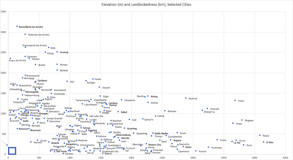
There is a lot happening in this chart, so let’s walk through it together:
- See that blue box in the bottom-left corner: that represents the areas where about 35-40 percent of people in the world live, close to sea level and close to the sea.
- The Swiss Mis-conception: Switzerland is sometimes used as a way to downplay the significance of geography. If the Swiss are so rich, what excuse do other poorer mountain countries have? Well, you can see part of the flaw with that line of thinking here: Swiss cities are neither high above, nor far from, the sea. Zurich and Geneva (and all the other Swiss cities too, though they are not shown on this chart) are at the very bottom-left, less than 500 metres above sea level and less than 500 kilometres from the nearest coast.
- European(/Mediterranean) exceptionalism: As with Zurich and Geneva, even the highest-elevation or furthest inland European cities are in the bottom-left of the chart, near sea level and near the sea coast. Specifically, you can see Madrid just over 500 metres above sea level, and Moscow just over 500 km from the sea coast. Similarly, in the Mediterranean regions outside of Europe, you can see Damascus about as high up as Madrid, and Khartoum a similar distance from the sea as Moscow. (Even though Khartoum is 2600+ km upriver on the Nile, it is only about 600 km across the desert to the Red Sea). Cities like Ankara (Turkey), Amman (Jordan), and Yerevan (Armenia) are near this corner of the chart too, though a few hundred metres higher above sea level than Damascus and Madrid. Most other European or Mediterranean cities would be too cramped to show: nearly all of them would be inside that little blue box. Even the highest small towns in Europe, such as Davos in Switzerland, are only around 1500 metres above sea level. That’s 100 metres lower than Denver, Colorado.
- The Extreme Edge: starting in the bottom-right, the big standout is El Alto-La Paz (population ~1.8 million) in Bolivia, which sits about 4000 metres above sea level. Other Andean cities, in Bolivia, Peru, Ecuador, and Colombia, are in this corner of the chart as well. Further inland, most of the cities on the outer edge of the chart are in China, on the Tibetan plateau (notably, Lhasa and Xining), or in Yunnan province in southwestern China (notably Lijiang and Kunming, but also smaller, higher ones like Shangri-La), or in northwestern China in Gansu (Gansu’s capital, Lanzhou, is next to Denver here) and especially in Xinjiang (Hotan, Kashgar, and in the top-left corner, the trio of Bole, Yining, and even a city of ~4.5 million people: Urumqi.) Also in this area of the chart are cities in Xinjiang’s fellow stans, such as Kabul (Afghanistan), Almaty (Kazakhstan), Tashkent (Uzbekistan), Skardu (Pakistan), Bishkek (Kyrgyzstan), and Osh (Tajikistan). Finally, furthest inland of all is Novosibirsk, which with a population of about 1.6 million is actually the third largest city in Russia (though still much smaller than Moscow or St Petersburg). It is followed by Oskemen in Kazakhstan (pop. ~300,000), a city near where the borders of Russia, Kazakhstan, Mongolia, and China’s Xinjiang region meet. Just behind them are a number of other cities in Russian Siberia.
- Siberian cities like Novosibirsk raise the question of whether or not the Arctic Sea should count for the purposes of this chart. I’ve included Novosibirsk, Oskemen, Krasnoyarsk (Russia), and Surgut (Russia) twice, once not counting the Arctic Sea – “ex-Arctic” – and once counting the Arctic Sea. As you can see, “Novosibirsk (ex-Arctic)” is over 3000 kilometres inland, whereas Novosibirsk’s distance to the Arctic Sea is only around 1600 km, putting it closer to cities like Minneapolis and Winnipeg (not counting Hudson’s Bay) on the chart. Oskemen, in contrast, is still close to 2500 km from the sea even when you do include the Arctic. That is still about 700-1000 km further than the “poles of inaccessibility” – the furthest spots inland – of Africa or the Americas. You can see some of the furthest inland cities in those continents on the chart, such as Kisangani (DR Congo), Bismarck (US), or Cuiaba (Brazil), all around 1500 km from the coast.
- I’ve bolded the names of certain cities, either because they are very large or because they are medium-sized cities that are very high up and/or very far from the sea. In a few cases, most notably Mexico City (followed perhaps by Addis Ababa in Ethiopia and Bogota in Colombia), a city is very large and very high up. In contrast, there are no very large cities further inland than about 1000 km, around where cities like Lahore, Chengdu, Chicago (if you don’t count Great Lakes), Kigali (if you don’t count other Great Lakes) and Kabul are situated.
- For the most part, I have limited “city” to places with populations of at least 100,000. This leaves out even more remote settlements; the highest of which, La Rinconada in Peru (pop. ~17,000), is another 1000 m or so higher than El Alto. There are a few exceptions, however, where I have included smaller cities, mostly around the outer edge of the chart. These include, for example, Cheyenne (pop ~64,000) the capital of Wyoming, Santa Fe (pop ~84,000) the capital of New Mexico, Timbuktu (pop ~55,000, in 2009) in Mali, or Tamanrasset (pop ~93,000, in 2008) in the Algerian Sahara. (In a future home-baked chart we’ll look at the elevation and landlockedness of extreme towns and settlements, sea cliffs, and mountain peaks).
- Many of the cities ranged along the y-axis are in the Americas or the former Soviet Union.
Many are upstream on major rivers, such as Manaus (the Amazon), Minneapolis and St Louis (Mississippi), Delhi (Ganges), Lahore (Indus), Chengdu (Yangtze), Xian (Huang he, aka Yellow), Juba (White Nile), Ascuncion (the Paraguay River, upstream fron the Parana), Kisangani (Congo), Perm and Moscow (eastern and western tributaries of the Volga, respectively) and various Russian cities located on major Siberian rivers that flow north to the Arctic. Several are also next to or near great lakes, like Chicago (Lake Michigan), N’Djamena (on the formerly great Lake Chad), Winnipeg (Lake Winnipeg and its neighbours), or Irkutsk not far from the very great Lake Baikal. - Most the cities ranged along the x-axis are Latin American or in regions near the Indian Ocean (the Middle East, eastern Africa, southern Asia, etc.). You can see, for example, a city like Caracas (Venezuela’s capital), roughly 900 metres high yet only about 10-20 km from the sea. Or, close to it, Sao Paolo (Brazil’s megacity), over 750 metres high yet only about 50 km from the sea. Near Sao Paolo on the chart another big city is Bangalore, in southern India, 920 meters high and about 265 km from both India’s western and eastern coasts. Nearly all these cities are in the Tropics; several, like Nairobi in Kenya and Quito in Ecuador, are next to the Equator. A number of the other capital cities around the Horn of Africa region are even higher than Nairobi is: Addis Ababa in Ethiopia, Asmara in Eritrea, and Sanaa in Yemen.
- Finally, there is that busy middle cluster of the chart, between about 1000-1500 metres above sea level and 500-1000 kilometres inland. This is, roughly speaking, the Persianate section of the chart, centred on Tehran but ranging widely across Iran and much of Central Asia to include cities like Isfahan, Tabriz, and Shiraz (which are higher but closer to the sea) on one side and Mashhad, Herat, and Dushanbe (which are lower but further from the sea) on the other. Along with Tehran, several other capital cities are here: Brasilia (Brazil), Kathmandu (Nepal), Lusaka (Zambia), Lilongwe (Malawi) and Kampala (Uganda). And for North America, there is Calgary and Salt Lake City.
