Countries frequently get compared to one another, and so do provinces and states and territories within countries. But we don’t usually compare provinces or states in different countries to one another. Let’s do a bit of that now.
Largest Populations

Above are the world’s 34 most populous ‘first-level administrative divisions‘ – provinces and states and territories and the like.(Statoids, they are sometimes called). 17 of the 34 are in China. 11 are in India, including the largest by far, Uttar Pradesh, which is home to more than 200 million people. All are in Asia except for Sao Paolo in Brazil and California in the US.
Some of the largest of these places used to be even bigger than they are now. Uttar Pradesh lost about 5 percent of its population and 18 percent of its territory when the Himalayan region Uttarakhand broke off to become a state of its own in 2000. Sichuan, formerly China’s most populous province*, lost about 26 percent of its population and 15 percent of its territory whenChongqing was separated from it in 1997. China’s most populous province today, Guangdong, lost about 8 percent of its population and 16 percent of its territory in 1988 when the island of Hainan became its own province. And Andhra Pradesh, formerly the most populous state in southern India, lost approximately 39 percent of its population and 41 percent of its territory when a new state, Telangana, was created in 2014.
*Sichuan was also formerly the world’s most populous province✝︎, before Uttar Pradesh overtook it around 1960. Back then, both had about 70 million people. Today Sichuan has 80 million, whereas Uttar Pradesh has ∼240 million. Uttar Pradesh’s population has grown by approximately 80 million since 2000, when Uttarakhand separated from it.
✝︎This is not counting the Russian Soviet Federative Socialist Republic, the largest constituent republic within the USSR. The Russian republic had nearly 120 million people in 1960. If it had been a country, it would have been the fourth most populous in the world. Whereas today Russia has only the world’s ninth largest population. Even if the USSR were to exist today, its population would now not be very much larger than that of Uttar Pradesh.
Provincial Population as a Percentage of National Population

This chart above shows the size of countries’ largest provinces or states in relation to their overall populations. In the US, for example, it shows that the largest state (California) is home to approximately 12 percent of the country’s total population. In Canada, by contrast, the largest province (Ontario) is home to about 38 percent of the Canadian population. Argentina has a similarly high percentage of its population living in its largest province (Buenos Aires), but it also has a much bigger divide between its largest and second largest provinces than Canada or most other countries have.
The only country ahead of Argentina on the graph above is Pakistan, where the largest region (Punjab) has about 47 percent of the country’s population and the second largest (Sindh) has about 27 percent. But then, Pakistan only has 7 regions, whereas Argentina has 24 provinces.
I’ve tried to take this into consideration in the graph below. In this graph, the x-axis shows the number of first-level administrative divisions that each country has, while the y-axis shows the percentage of the country’s population that lives in its largest administrative division:
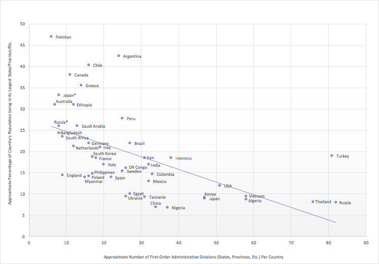
You can see that Argentina is still an outlier here. (As is Turkey, on the opposite end of the chart. Turkey has 81 provinces, but a sizeable chunk of its population lives in its largest one, Istanbul). In fact, not only is Buenos Aires by far the most populous of Argentina’s 24 provinces, but it also surrounds the “Autonomous City of Buenos Aires”, which is itself the fourth most populous administrative division in the country:

Combined, the two Buenos Aires’ account for about 45 percent of Argentina’s population. This partly reflects the fact that Argentina is a highly urbanized country; its population is tied with Japan’s and the Netherlands’ at 92 percent urban, according to the World Bank, which is higher than in any other major country. In Argentina’s closely contested presidential elections in 2015, the two candidates vying to become president were the governor of the province of Buenos Aires and the Chief of Government of the Autonomous City of Buenos Aires, respectively. (The current president, elected in 2019, previously served as a legislator in the Autonomous City of Buenos Aires). Buenos Aires also directly borders the country’s second and third most populous provinces, Cordoba and Santa Fe. Together Buenos Aires and its neighbours account for about 75 percent of Argentina’s population.

Argentina’s long neighbour Chile is similarly urbanized (88 percent of its population lives in an urban area), and similarly has more than 40 percent of its population living in the largest of its (16) regions, the Region Metropolitana de Santiago, where the country’s largest city is located. Santiago’s province is also surrounded by Chile’s fourth and fifth most populous provinces.
As compared to the other outliers on the chart above (perhaps only with the with the exception of Japan) – Pakistan, Canada, Ethiopia, Peru, Turkey, to a certain extent even Australia – Argentina and Chile are both also homogenous countries, without regional linguistic divisions, large immigrant populations, or their largest cities separated by great distances. Japan and Argentina especially do not have many immigrants (though Argentina used to, a century ago): foreign-born residents are around just 3-4% of their total populations. Their combination of demographic centralization, homogeneity, and geographic isolation is arguably unique, at least among major countries.
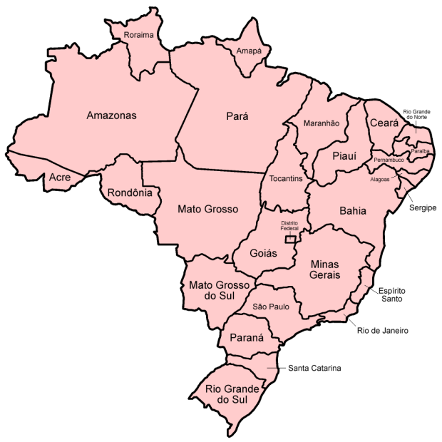
Brazil too is highly urbanized (87 percent urban), but unlike Argentina and Chile, its second largest city, Rio de Janeiro, is not so much smaller than its largest city, Sao Paolo. Brazil has 27 first-level administrative divisions, the largest of which, Sao Paolo state, is home to about 22 percent of the country’s population. The country’s three most populous states (Sao Paulo, Minas Gerais, and Rio de Janeiro) directly border one another, and together account for 40 percent of the population.

In other big countries, like the United States, China, and India, the most populous provinces or states account for a smaller share of the total population. Guangdong is home to about 9 percent of China’s total population, California 12 percent of the US population, Uttar Pradesh 16.5 percent of India’s population.
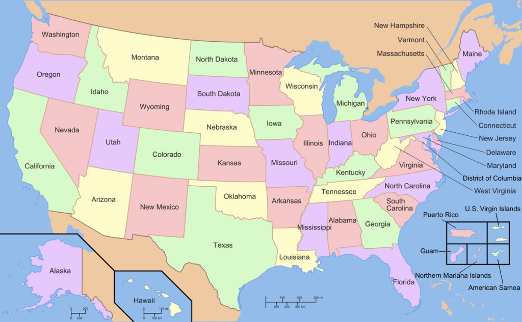
In the US, even clusters of states are fairly small: California and its immediate neighbours combined are home to only about 15 percent of the US population. A similar 15 percent is in New York state and its immediate neighbours, or – overlapping somewhat with New York – in Pennsylvania and its immediate neighbours. Texas and its immediate neighbours account for only about 12 percent of the US population.

By comparison, Guangdong and its immediate neighbours are home to about 24 percent of China’s population. In the more populous northern part of China, the province of Henan and its immediate neighbours have about 33 percent of China’s population. And in India, Uttar Pradesh and its immediate neighbours have about 42 percent of the country’s population (not counting Nepal, which it also borders). Uttar Pradesh’s southern neighbour, Madhya Pradesh (“central state”, whereas Uttar Pradesh means “northern state”) and Madhya Pradesh’s neighbours together have an even higher 46.5 percent of India’s population.

In Germany, the fifth most populous German state, Hesse, directly borders all five of the other most populous German states (North Rhine-Westphalia, Bavaria, Baden-Wurttemburg, Lower Saxony, and Rhineland-Palatinate). Together Hesse and its neighbours account for 78 percent of Germany’s total population. Hesse’s chief city is Frankfurt, a European finance and transport hub. The most populous of Germany’s 16 states, however, is North Rhine-Westphalia, home to 21.5 percent of the country’s population. Its largest city is Cologne. It is also the only state to border both the Netherlands and Belgium, both of which are densely populated too.

In France, Paris’ Île-de-France region similarly has just under 20 percent of the population of France’s 13 non-overseas regions, with about 12 million inhabitants. Along with its five neighbouring regions Île-de-France has almost half of France’s total population. (France also divides its territory into 101 departments, 5 of which are overseas. The biggest department – with 2.6 million people – borders Belgium; the second biggest is in Paris).
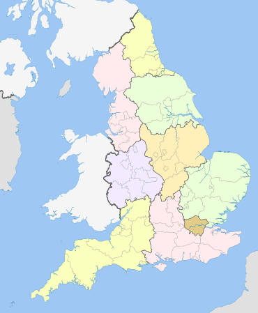
On the graph earlier, I included England, rather than Britain as a whole. Britain has four constituent countries (England, Scotland, Wales, and Northern Ireland), England of course being the largest of these, with 84 percent of Britain’s population. Within England, none of the nine regions shown in the map above has more than 15 percent of the English population. The three southeastern regions – London and its two surrounding regions – have about 45 percent of the English population (and so about 38 percent of Britain’s total population).

A less demographically lopsided archipelago is Japan, where the largest regions are located in the centre of the country. This map shows 8 regions and 47 prefectures; the largest region (Kanto, shown in green) accounts for about 34 percent of Japan’s population, while the largest prefecture in that region (Tokyo) accounts for about 10 percent of Japan’s population. The three central regions (Kanto, Chubu, and Kansai, shown in green, turquoise, and purple here) together are home to 97 million people, about 77 percent of the country’s population.
Largest Economies
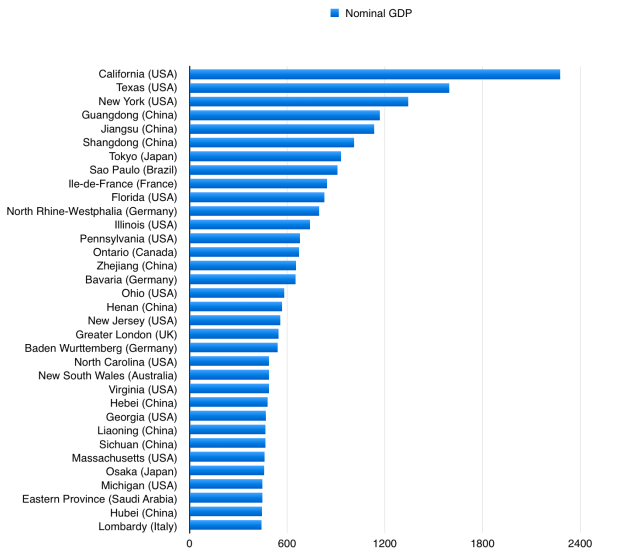
Above are 34 of the largest provincial economies, ranked by gross domestic product (in nominal terms). 13 of the 34 are in the USA, 9 are in China, and 13 are in other countries. Japan’s Tokyo prefecture had the largest GDP here apart from the three largest American states and Chinese provinces, but if we were to have used Japan’s biggest ‘region’, Kanto, in which Tokyo is located, it would have had a larger GDP than any state or province other than California. Then again, if we were to add Hong Kong’s economy to that of its close neighbour Guangdong, its nominal GDP would be about the same size as Japan’s Kanto region.
(Of course, these are just estimates of gross domestic product; economic figures such as these should be taken with an especially large grain of salt. They’re subject to error and change, and are only meant to approximate the income of an economy, rather than the net worth).
The largest of these places have economies bigger than those of major countries. California’s nominal GDP is greater than Britain’s, France’s, or India’s. Combined, the first-level administrative divisions shown on this chart account for between a quarter and a third of global economic output.
Largest Territories

Finally, here are the 30 largest administrative divisions in terms of territorial size (in square kilometres) on land. All 30 of these are larger than France. The largest of all, Russia’s Republic of Sakhka (also known as Yakutia), is nearly as large as India. 7 of the 30 places on this list are in Russia. 7 are in Canada. 5 are in Australia; that’s every Australian state apart from Victoria (the state where Melbourne is the capital city) and the island-state Tasmania. 4 are in China, 4 are in Brazil, 2 are in the US, and 1 is in Chad.
Before 1999, when Canada’s largest administrative division, Nunavut, broke off from the Northwest Territories to become its own territory, the Northwest Territories was the world’s largest region. But its population was tiny: it had only about 70,000 people. Yakutia’s population, in contrast, is roughly 1 million. Alaska’s population is roughly 730,000.
Combined, these 30 administrative divisions occupy approximately 27 percent of the world’s land outside of Antarctica or Greenland. Yet they are home to only about 2.5 percent of the world’s population, 195 million people. Roughly two-thirds of this population lives in Texas, Xinjiang, Inner Mongolia, Minas Gerais, or Ontario.
Additional Notes:
- In the 19th century United States, Virginia was the fifth most populous state in the country and the most populous state in the Confederacy, before West Virginia broke away from the rest of the state during the Civil War in 1861, taking about 23 percent of Virginia’s population and 36 percent of Virginia’s territory with it. Like Uttarkhand which became a state in 2000, West Virginia was the more mountainous part of the region it broke off from. Virginia’s population before the split was only 1.6 million (including 491,000 slaves); today West Virginia alone has 1.7 million people, though it is the only state to have a smaller population today than it did in 1950.

One Reply to “”